MAP 5
The motorway and primary road network of Ireland
I will use a series of maps to try to explain in a simple way the reasons why roads are designed the way they are. I will follow the explanations behind it by using a few basic maps. Have you ever wondered why roads are not a straight line between two cities like Galway and Dublin or between Wexford and Dublin? It is obvious that the shorter distance between two points is a straight line. It would be cheaper, simpler a quicker to build it in that way. Keep reading to know a bit more about road design.
Let's start from the basic. I will show a map of the island of Ireland with the main roads (Motorways and Trunk Roads). Feel free to explore it and I want you to start thinking why the roads were laid there.
This first map has been created by getting the roads data from OpenStreetMap (OSM). Once the data was imported to qGIs, then a symbol for each category was used to create and edit the map having in mind it was going to be displayed on the website: Pop up windows have been added, the zoom has been locked to the area of Ireland. The colour of the roads matches the colour of the signage for Motorways and Trunks/Main Roads. As a final step, the plugin qgis2web was used to export the map in order to view it interactively on the web without any programming skills.
The result is shown below. Before you explore the map, please click on the information "i" icon located at the bottom left corner of the map to get more instructions.
The map above is a basic map that just shows the main roads. A basic background was choosen to make the symbology (roads) stand out as I wanted you to focus on the roads. The map below shows a wider range of graphical information to explain why the roads are where they are. They connect points. In some instances they connect two cities (Dublin with Limerick via the road M7), towns with cities ( Cork with Tralee via the road N22) or they lead to an airport or a port/ferry, like the road N25 from Wexford to Rosslare Harbour.
Zoom in to explore the name of the roads between two cities, or they name of cities, towns, airports and ports. Before you explore the map, please click on the information "i" icon located at the bottom left corner of the map to get more instructions.
The fact that a main road connects two cities or towns is not something new for anyone. I want to drag your attention to the question why the roads are not a straight line between two main cities like Dublin and Cork. There are few reasons. One of them is safety. Driving on gentle curves is safer because it is easier for drivers to maintain focus and control, compared to long straight stretches. Look at the map below and I challenge you to think about another reason why roads are not always following a basic straight line. Explore the road that connects Cork to Killarney or the road between Limerick and Waterford just to name two instances, and think why the road is laid there.
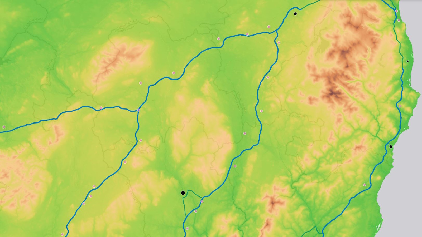
This map has been created by using the SRTM Downloader plugin in qGIS. Note the data was downloaded from NASA website. Once the data was imported to qGIs, then a green colour was used for indicating low elevation, while brown colour was used for higher elevations. The values below 0 were ignored for a better displaying of the data. As a final step, the plugin qgis2web was used to export the map in order to view it interactively on the web without any programming skills.
As I am sure you have guessed, the main reason why the roads follow a curve path is to avoid obstacles. In this case, mountains. Try turning off and on the layers, especially the roads to explore in detail the topography or Ireland and how roads are usually laid on the the lower altitude areas (symbolised by the green colour in the topography layer), avoiding the hilly areas. Sometines roads cross through a mountain pass, which is a navigable route through a mountain range, when it is no possible to avoid it. Now we are able to understand how roads are usually designed by (1): connecting points and (2): following the topography. Let's explore the last map that it is somehow connected to the two previous instances.
Another reason why roads are as they are, it is because the history. Before the first roads were ever built as today we know, people used to travel to their nearest village by using ancient paths or tracks that connected two near settlement. Over time some villages were growing, being the node that conneted many other villages or even towns. Everything started by connecting short distances between two points or settelements, by using the easier route: i.e. avoiding mountains, rivers, or any other obstacles. With time, those ancient paths were being used more often and connected to a more extended grid. With technology, those paths became roads, by using new materials. But the settlements location (villages, towns, cities) was unchanged. Motorways sometimes follow the same layout as a previous road, that was a path/track back in the time. With the technology that we have nowadays, we would be able to build a straight road between two cities, but we need to have present that we need to maintain the cities/towns by using bypasses. We could say that a city is an obstacle from a perspective of a motorway design. If you zoom in the last map, you will realise how the roads, especially motorways, avoid the nodes shown in light pink colour. On the other hand, the trunk roads (see for example the road from Limerick City to Cork), passes through a few towns (Charleville, Buttevant, Mallow). A potential Motorway between those two cities would avoid those towns by the use of a bypass, like the ones you can see in ay other motorways.
In conclussion, roads are not straight lines due to safety concerns like driver fatigue, and obstacles such as existing cities, land divisions and physical terrain (rivers, mountains), and becuase the roads usually follow ancient or old tracks/paths that were being upgraded progressively from paths to roads and then to motorways. Building bridges or tunnels instead of curved roads is often avoided due to significantly higher costs, construction time, and potential for environmental disruption. While tunnels are sometimes used for steep grades, they are even more expensive than bridges and require extensive systems for ventilation and safety. Curved roads are a cheaper alternative that can be designed to manage speed and avoid obstacles, even if it means adding curves instead of a straight path.